1998 Leonid MAC
The following arguments decided the chosen flight path:
- Leonid "storm" component (only visible over eastern Asia):
- main peak between 17:00 - 21:00 UT November 17, 1998
- duration: 1-3 hours (sharp maximum)
- peak rate of order 100 to 10,000 /hr
- rich in faint meteors
- peculiarities: there may be a background component to this peak that is longer
in duration
- observing strategy: western most location for flight route. Ground stations in
China for coverage of flux after 21:00 UT.
- Leonid "filament" component (visible all over the world):
- peak expected at passage of node (but returned 0.6 days early).
- duration: up to 3 days. Rates elevated in nights of Nov. 16/17, Nov. 17/18
and Nov. 18/19.
- peak rate about 300 per hour
- rich in bright meteors
- peculiarities: time of the peak was 0.6 days earlier than expected
- observing strategy: none.
|
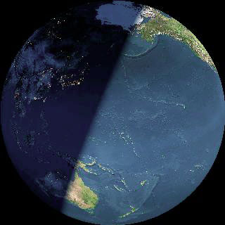
Earth from the perspective of the Leonid shower at the time of passing the comet orbital plane at 19:43h UT, 1998 Nov 17.
|
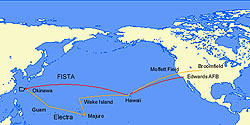
The route of the aircraft during the Leonid MAC 1998 mission. FISTA and Electra
followed a different route to Okinawa (Kadena AFB)
due to different aircraft range. On Nov. 17/18, we
circled over the East China Sea.
|
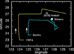
Mission flight path: detail of airplane route on peak night. FISTA was circling the
Electra aircraft, both following a pentagon shaped path. At 20:52:06, a bright
fireball made FISTA change course briefly for better viewing.
|